Totara Flats, Tararuas
A little while ago, I blogged about the trip to Powell Hut. This post decribes an alternative trip into the Tararuas, from the Waiohine road-end into Totara Flats Hut. I found this trip much more challenging than the trip up the Gentle Annie track to Powell Hut, but at the same time a lot more fulfiling.
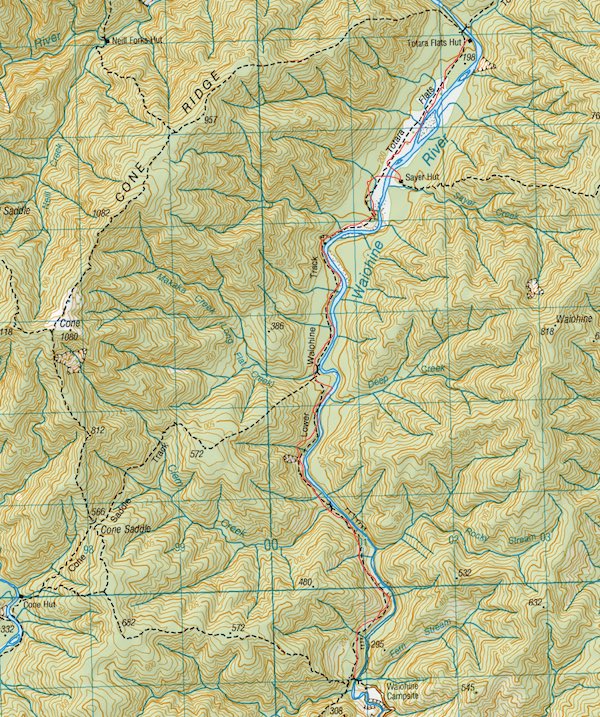
The track, marked in the thin red line View Topomap in browser
We began the track from the Waiohine road-end. The road-end is reached by turning off just after the bridge over the Waiohine River just outside Greytown, and then following a narrow but sealed country road. After crossing the railway tracks keep an eye out for the turn off on your left - it’s just marked with an old yellow AA sign, and I missed the turn at first.
The road soon turns into gravel but is a great drive up the gorge towards the picnic area. It’s similar to the Otaki Gorge road, but not as long or windy. After heading through the picnic area, a turnaround bay is reached with a chain across the road. In 2008 a large slip and washout closed the road further up, and while repairs are going on the road is impassable. I’ve not heard either way about the security at this carpark, but there were several cars parked there when we walked.
Leaving your car at the turnaround area, you can cross the chain and walk up the road. You’ll reach the slip after about 5-10 minutes, with the campground another 5-10 minutes after that.
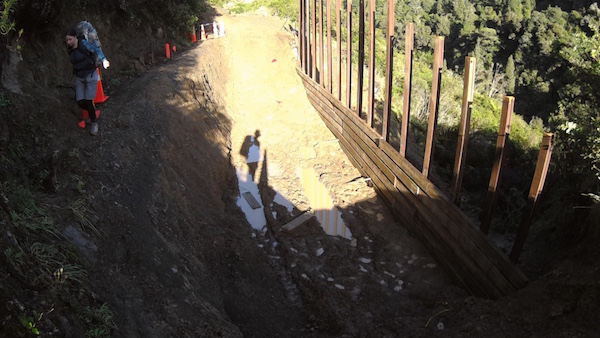
This was the slip & washout when we were there. Repairs have started so it may be easier to cross soon - but progress is slow.
The campground has been a popular spot in the past, but cutting off road access gives it a strange abandoned air. It’s no longer serviced but there is plenty of space for camping, and flush toilets here, if you are planning on stopping overnight.
To get to the tracks into the park, you’ll need to cross a large swing bridge. This bridge is pretty recent, but due to it’s size and positioning in the narrow gorge you can expect some movement when the wind is blowing. It’s quite high up above the river but a nice uphill slope allows nervous trampers to look uphill and focus on the end of the bridge.
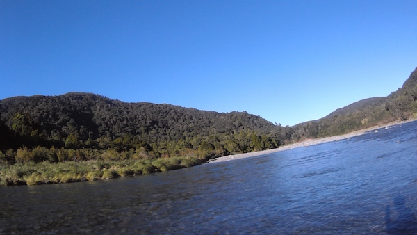
After crossing, there’s a intersection, with the left hand fork crossing over a ridge and dropping to the Tauherenikau River and Cone Hut (apparently about 2-3 hours), and the right hand fork turning to follow the gorge up towards the flats. Taking the right hand fork, the track condition soon deteriorates into large (semi-continuous) mud pools along the track route, interspersed with large tree roots. The track condition was a slight shock to us after the well-maintained Gentle Annie Track, but seems more typical of the classical tramping tracks in the Tararuas.
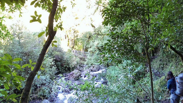
The track carries on up the gorge, undulating along the river bank. Typically the track is routed over small bluffs so expect steep but short climbs and descents. There are several small streams and creeks along the gorge, but all major crossings are fitted with swing-bridges (The bridges don’t look terribly old and they are not on the topo map, so I imagine they were all done in one go). After about an hour, you’ll reach a nice Beech clearing just before Clem Creek. A good spot for a rest, and it’s looks like a popular camping spot judging from the number of old campfires. Clem Creek is about halfway along the narrow gorge section before opening out onto the flats so is also a good milestone to judge progress. The next hour continues much as the first - mud and roots.
One of the small swing-bridges over the smaller creeks going up the gorge
About halfway between Clem Creek and the flats you’ll reach an intersection with another track that heads over Cone Saddle and continues to Cone Hut to meet the left-hand fork of the track from the swing-bridge. This seems like a nice overnight trip that is on our to-do list, although I’ve read that the track continues to be muddy and rutted.
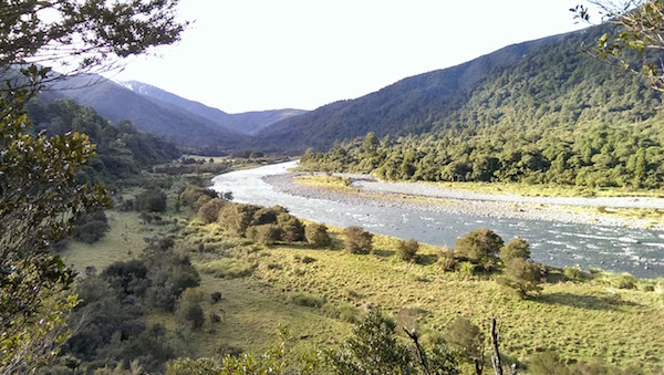
Soon after the intersection is an impressively large old slip - there are two options for getting around it, both marked - either the river route or climbing up and around the slip. I recommend the river route unless the river is in flood - the slip is a lot larger than it looks from the intersection. Clamber down the river bank and then head upriver keeping an eye out for the orange triangles that mark the exit point for the diversion at the beginning of a short section of open grass. Keep an eye out from now on for sign of deer and pigs, both apparently common in this area. After the short bit of flats, the track climbs again steeply around some bluffs, and then drops back to the main body of flats.
If you’re interested in checking out a historic hut, and don’t mind getting your boots wet, after joining the flats head off the track to the river. You should emerge within sight of a small rapid that diagonally crosses the river, with the end closest to you slightly further upstream. You can cross the river here in the right conditions and check out Sayer’s Hut, an old Forest Service hut constructed of native timber with an open fire. Finding it from the river can be a little tough, but there are clear trails climbing the river bank after you cross the river that should get you within sight of the hut - it’s not directly visible from either bank of the river. We crossed over to the hut on the second day on the way back down the valley, but doing it on the first day probably makes more sense - less distance to travel in wet boots after crossing back over the river! The hut itself is in a lovely spot tucked into the bush back from the river, and this is also on our to-do list for an overnight trip. It sounds as though it doesn’t get frequent visitors - mostly locals and hunters.
The river crossing point we used to reach Sayer’s Hut (a little wonky!)
From the crossing to Sayer’s the Totara Flats Hut is a quick walk up the valley through the grass. After the tough terrain up the gorge, the grass is a bit of a treat. Soon before reaching the hut, you’ll head back into some scrubby bush - the hut is 5 or 10 minutes on from this point.
Totara Flats Hut is a 26-bunk hut, so there is plenty of space. It’s often used as an alternative to Powell Hut, as the track that you have travelled on continues to the head of the valley and climbs to meet Gentle Annie track near Mountain House. The hut is a pretty standard design, with two bunk rooms and a common area with a mixed-fuel (wood/coal stove). There used to be gas cookers provided here, but DOC has removed them (though they’ve left the hut fee the same at 3 tickets ($15) per person - pah!). We had a slightly chilly night after the rain during the week, as there wasn’t much dry wood available. If you use some of the dry firewood from the wood shed, don’t forget to pop a bit more under cover to dry out for the next group! Also a hut to watch out for rats in - there were droppings everywhere when we were there - probably due to the quantity of food and little bits and pieces left behind by others. We initially had the hut to ourselves but were joined later in the evening by a couple of others who had diverted from Powell Hut due to ice higher up.
The following day there are a couple of options. We had been hoping to do a long day, heading back down the valley to the track turnoff to Cone Hut, and then crossing over the saddle and back over the ridge back to the Waiohine Swing-bridge, but after seeing how long it took us to get up the valley we decided to head back the the way we came. On the way back we took our time a little bit more, and checked out a couple of geocaches on the way. It did take us about the same amount of time to get out as it did to reach the hut, so we must have been moving a little faster - perhaps because we weren’t trying to keep dry boots for as long as the first day!
The whole trip up the valley took us pretty much bang on the DOC time of 4 hours. We normally do slightly under the DOC time, but the tough terrain certainly slowed us down - the roots require a lot of clambering and can be a bit slippery. This is also the trip on which we decided we needed a personal locator beacon - the country is beautiful, but has an air of inaccessibility. Despite all this, this is one of the best overnighter trips I’ve ever done. The closed off road, the steep and tough terrain, and the solitude in the valley (we saw 3 people in two days), makes for a fantastic escape. I highly recommend it!