Powell Hut, Tararuas
The Tararua ranges have a fearsome reputation in New Zealand. Frequently cloudy, snowy, rainy, misty, almost always windy, and very occasionally, sunny (though not to be trusted). Despite this bad rap, they are accessible, scenic, and have a broad range of trip options - from short dawdles through the bush to challenging alpine tramps over the tops.
With Wellington so close by, these ranges offer so much. If you’re a Wellingtonian, there’s something there for you. Today, I’m going to be talking about a perfect intro trip - from the Holdsworth carpark near Masterton to Powell Hut and back. If you live anywhere within a 2 hour drive of this trip, it’s a must-do. It ascends gently from a river valley, travelling up through beech forest and subalpine bush and popping out above the bushline straight before the hut. In winter, you can expect to see snow around, but there shouldn’t be enough of it to worry too much.
I’d consider the Holdswork carpark to be the main entry to the Tararuas, along with Otaki Forks on the Western side of the range. The carpark is just over 90 minutes drive from central Wellington along State Highway 2. The turn is between Carterton and Masterton (though closer to the latter), and is signposted ‘Mt Holdsworth’. There’s a small wood pulp processing plant (from memory, it’s something of the sort) next to the turn, so you can keep an eye out for the chimney stacks from that. Drive past the farm supplies place and the livestock sales yard and head along the rural road for about 15 kilometers until it narrows and then goes through the gate into the Holdsworth campsite. This campsite isn’t particular interesting as a destination in it’s own right, but can make a good staging post if you’re travelling from the city in the evening (Camping is DOC-standard $6 adult per night which will get you a grass spot of your choice, a cooking shelter and flush toilets).
This carpark should be safe to leave your car (plenty of others do) - the ranger’s house is just up the driveway next to the carpark and while there’s campers around this should deter most - but take all precautions - don’t leave valuables in your car, make sure all the doors are locked etc. Don’t forget to make sure you’ve turned your headlights off!
The track starts along a gravel road that goes to Holdsworth Lodge, a DOC managed accomodation facility that offers group or sole-occupancy room options. There’s an intentions book on the left hand side as you face the lodge where you should write down your plans and when you’re expecting to be out - this will be the first thing that is checked if somebody has to come and find you. Once you’ve done that, the road carries on just past the lodge then becomes a narrower quad-bike-width track before reaching the bridge over the Atiwhakatu Stream.
The track up towards Powell Hut is the aptly named “Gentle Annie” Track. For the first few minutes, it follows alongside the stream. The track is wide here with a good surface. Expect to see a few locals with walking their dogs (and kids!). After 10 minutes or so you’ll reach an intersection - the track continues straight ahead up the Atiwhakatu Valley, passing through the Donnelly Flat picnic area about 15 minutes after the intersection, eventually reaching Atiwhakatu Hut.
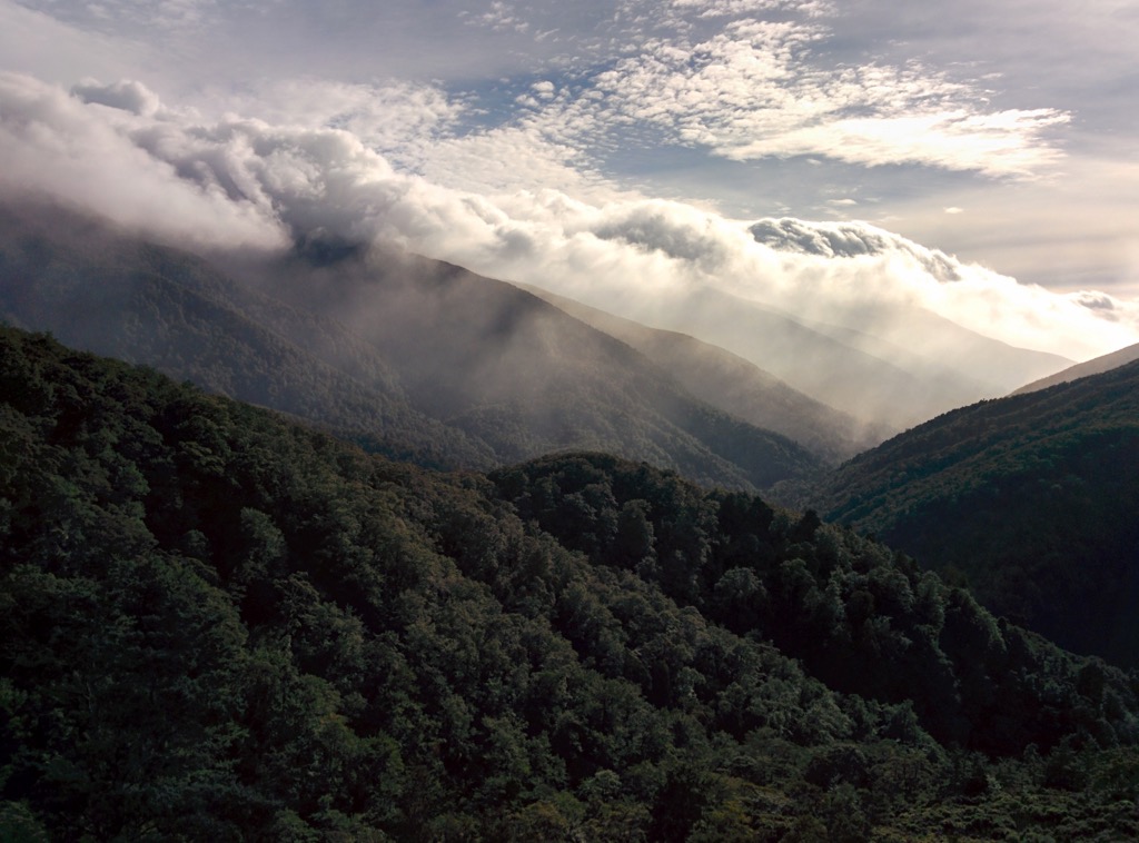
The Gentle Annie track narrows from the quad-bike sized track to more of a normal bush track - though the track surface remains excellent. It quickly enters a small valley, climbing up a spur towards the first stop, Rocky Lookout. The climb can be steeper in places, but there’s steps everywhere there should be, and plenty of places to pull over for a breather. Eventually you’ll reach the head of the valley and begin to traverse around the hillside, before joining another short spur for another bit of climbing. Eventually, you’ll emerge from the Beech forest, and if you look up the hill, you should see the railings of Rocky Lookout above you. This is a great spot with fantastic views. The rock the lookout is based around is fun to climb, and it’s a good chance to get your breath back, have some water and food. Expect the track from Holdsworth to Rocky Lookout to take between 30 and 40 minutes with one or two breather breaks on the way up. At Rocky Lookout, keep an eye out to the left for Powell Hut high up on the bushline.
Fortunately, after Rocky Lookout there’s a bit more of a gentler climb up the last remaining bit of spur before reaching a saddle, where the track turns and begins to climb along the hill. It’s pretty easy going, with an easier gradient as it continues around the hill before meeting the start of a ridge where there is a key intersection and a couple of benches about 30 minutes after Rocky Lookout. Another good spot for a rest and some water! Going straight at this intersection descends down a valley to the Waiohine River and Totara Flats Hut, which can be a good bad-weather alternative to Powell, but turn right to head towards Mountain House, the next landmark on the way to Powell Hut. The track climbs just a little more, before flattening off, crossing a couple of boardwalked sections, and then descending moderately to Mountain House. This section allegedly takes 20 minutes, but always seems to last much longer.
Mountain House can be a good place for a quick stop, but no doubt you will have been having to look further and further up to be able to see Powell Hut and may have a slight dread of the hill that is to come - best to make it a quick stop and get stuck right into it. The track climbs up along the hill for a short period, before zigzagging a couple of times and then starting to climb up the left hand side of a spur that goes all the way up to the hut. The trick to this bit is to take breaks as needed - the DOC time to get up this section is generous and already allows for a few breaks. There’s a flat bit next to a couple of drainage holes that makes a good spot for a break, as it’s about halfway up the bush part of the section before the views emerge.
Carrying on up the spur, you’ll eventually come to patchier sections of bush, and get into rockier terrain with steps on the steeper climbs to make things a bit easier. Watch out for ice at this level. There’s great views all the way up back down towards Holdsworth, down into the Waiohine Valley to Totara Flats, and out across the Wairarapa.
It seems like there’s always just one more ridge to overcome, but eventually you’ll pop up to a surprisingly flat section, with the hut just a few metres along the hill.
Powell Hut is a extremely popular hut, with bookings required in the summer months (Nov - Apr). In winter it seems to be variable, but with 28 bunks (plus plenty of floor space), it’s a pretty safe bet. There’s cookers installed with LPG tanks helicoptered in occasionally (making use of an interesting telecommunications system to send alerts), and a dual-fuel wood/coal burning stove for heating. This hut is a Serviced hut, which means it requires 3 hut tickets per person, which translates to $15pp. Hut tickets can be bought from DOC offices and some outdoors stores, and go towards paying for hut maintenance and servicing. There doesn’t seem to be a great deal of good camping sites nearby the hut, but if need be there’s probably a couple of places to wedge a tent. There’s a great outlook from the hut over the whole of the Wairarapa, and the deck is quite nice if it’s not too cold and/or windy.
Powell Hut was first built in 1939 by the Hutt Valley Tramping Club as a bit of a ski lodge - back in those days, a trip up to Ruapehu wasn’t quite as easy as it is today, and skiing in the Tararua’s was popular, both here and around Field Hut on the other side of the range. The hut was rebuilt as a Lockwood hut (as many NZ huts of that generate were, and are) in 1981, but burned down in 1999 (many huts burn down due to the fire being mishandled - for example hot ashes or embers escaping). In 2000 it was replaced by DOC and this is the iteration of the hut that stands today. This area is also the scene of an unsolved murder and even has a local ghost!
If you’re staying the night at Powell (or have made good time on the climb up), you can continue up to the summit of Mt Holdsworth during summer, if the weather is reasonable. In winter there is snow and ice at this altitude and it is not safe to go all the way to the trig without the proper experience and equipment. From the hut, the track climbs steeply up to the ridge, and then clambers over, around, and through tussock before reaching a turn off to High Ridge (I believe this descents to Cone Ridge above the Waiohine). This is as far as I’ve ever been, but I believe this turnoff is about halfway to the trig.
The descent is exactly the same as you came up (though there are steeper alternatives down from Mountain House to the Atiwhakatu Valley and out from there if you’d prefer a more difficult finish to the day). The steep bit down to Mountain House can be a bit tough on the knees and it’s worthwhile stopping once or twice on the way down this bit. After that it’s a nice doddle back down to Rocky Lookout, then the stream track back to the bridge, finally emerging at the carpark. Depending on how quick you are on the way down, the descent takes us about 2-2.5 hours, but will be longer if you stop on the way down as well.
From the carpark, it’s time to head back out to the state highway. On the way home, we usually can’t resist stopping off at The White Swan, for a bit of a treat!